Quito
Day 11 (1/11/18)
|
Day 11 began at 4:00 AM; we had a long drive to Quilotoa, our first stop of the day. Quilotoa is a water-filled caldera that formed approximately 600 years ago following a large eruption; it's similar to Crater Lake in Oregon. When we arrived, we were immediately greeted by two friendly stray dogs who looked very interested in our sandwiches. When we started our hike down to the lake, they followed us- and more stray dogs joined our group as we got closer to the water. The hike down was very steep and slippery; I was glad I would be taking a mule back to the top.
|
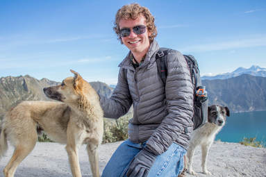
Posing with Gringo (front) and Mocha (back). Yes- we named them.
|
|
Feeding the dogs at Quilotoa.
|
When we got down to the lake, we were greeted by even more stray dogs, as well as a chicken. There were kayaks and canoes available to take on the lake, but there was no one working to rent them out. After relaxing at the bottom for a while (and feeding the dogs a bit more), everyone who wasn't taking a mule began the difficult hike back to the rim. Those of us taking the easy way waited at the bottom a little longer for our mules to arrive before heading up ourselves. It was pretty satisfying to pass our comrades as they struggled up to the top; when we got to the top, we enjoyed amazing $0.50 empanadas from a hostel across the street while we waited for everyone else. |
We eventually had to say our goodbyes to the dogs, which of course was disappointing (Gringo tried following us onto the bus and we had to close the door on him ☹ ). But, we had to keep going- our next stop was lunch at Hacienda La Cienega, where we were serenaded by the talented in-house band. After lunch, we drove to Cotopaxi, passing more invasive Canadian pines and roses for sale on the way; in Cotopaxi National Park (founded in 1975), the pines are diseased. Instead of removing them, the pines will be left to die on their own; eventually, native species will start to return.
|
Cotopaxi is one of the most active volcanoes in the world. It last erupted in 2015; during that eruption, it shot out a plume of ash 700 meters high. Cotopaxi's largest (known) eruption took place in 1877; thankfully, they now have alarm systems placed all throughout the park, so visitors and locals can avoid the deadly lahars (volcanic mudlows) which wreaked havoc in the past. Although there are no permanent human settlements in the park, it is not devoid of life- the park is home to white-tailed deer, rabbits, pumas, Andean wolves, Andean foxes, and more. Unfortunately, some of the "and more" are invasive species such as horses and cattle, which escape from nearby farms and destroy the ecosystem needed by the native species; they are often shot on-site for this reason. |
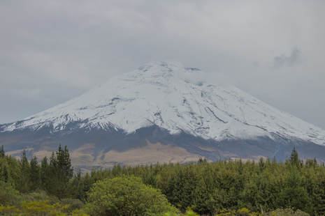
Our view of Cotopaxi, slightly obscured by the clouds.
|
It was too late to attempt climbing part of the volcano, so instead we took a shorter walk around a pond to a gazebo lookout point. While there, we ran into some French Canadian backpackers, who ended up hitching a short ride with us to their campsite on our way out of the park. After a short drive, we arrived in Quito and checked into our hotel. Finding a place to eat dinner was an interesting experience; every restaurant we passed had an employee outside trying to persuade us to come in, sometimes in a very in-your-face way. We eventually settled on an "American" restaurant, which turned out to be alright (although not very accurate). Day 11 was a very busy day, but it definitely stood out as a favorite to me. Quilotoa was absolutely amazing, from the caldera itself to all the stray dogs we befriended. When I eventually go back to Ecuador, I'll be stopping there again.
Day 12 (1/12/18)
Day 12's main activity was a city tour of Quito. Quito was the first city declared as a World Heritage Site by UNESCO; it has one of the best preserved historic centers in all of the Americas. Our city tour began with some of the city's largest churches (no pictures were allowed inside, unfortunately). Diego explained that the Pichincha valley (where Quito is now located) was first inhabited ~1000 BC by the Quitus-Caras people, who had determined the exact location of the equator. They were conquered by the Incas following the conquest of Cuenca; the Incas destroyed the Quitus-Caras temples and built their own on the equator. Not long after, the Incas were conquered by the Spaniards, who built their own churches on the equator. We first visited the Basílica del Voto Nacional, on which construction began in 1892 (it's technically still unfinished, due to a local superstition that the world will end when it's done).
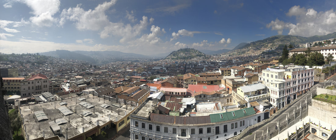
The view of Quito from La Basílica del Voto Nacional.
|
From the towers of the church, we were able to get a good view of the city. It sprawled for miles- past where we could see. This was partially due to the presence of photochemical and sulfurous smog, which was created and subsequently trapped in the valley due to the lack of air movement. We were also able to get a good look at the questionable infrastructure found throughout the city. People had built small shacks on top of other buildings, on hills only accessible by foot, etc. Tait explained that these people are trapped in a cycle of poverty; they can't afford connections to water and sewer lines, so they pay for water and showers elsewhere, which in the long run ends up costing more than a connection would in the first place. |
On the way to our second church tour, we stopped at a statue in the historic city center. Diego explained that in the past, the city was segregated; the enslaved indigenous population was forbidden from living in the city center with the wealthy Spaniards. The indigenous people were also forced to build many of the Catholic churches; in retaliation, they hid Inca crosses wherever they could, and defaced decorations like gargoyles and angels.
We visited a few more churches (including one containing 8 tons of gold leaf) before eating lunch at a mall food court and taking the Teleférico (cable car) up the side of Pichincha. It brought us up to ~13,000 ft; unfortunately, fog obscured our view of the city, so we headed back down almost immediately. Our next stop was the Pacari office building, where we got to taste a variety of their gourmet chocolate, as well as learn about their company. While they're certainly better than their competitors (Hershey, Nestle, etc.), we got the idea that they're hiding something behind their apparent sustainable business model. They pay farmers fairly, educate them on the chocolate-making process, and provide them with equipment/knowledge to prevent them from getting ripped off by other chocolate companies; but, they also allow their fine-aroma cacao trees to go extinct, and make no effort to save them. We had a debate about Pacari's true motives on our bus-ride back to the hotel, and it continued until the end of the trip.
|
Our tour ended with a ride of Quito's public bus system, which was both informative and anxiety-inducing. It's a brilliantly designed system, more similar to our railways than any US bus system (see pre-trip readings for more info about the bus system). After riding the bus back to our hotel, we took a few cabs back to the historic city center for dinner. It was largely the same as the previous night; there were restaurant employees everywhere begging us to eat at their establishment. We eventually settled on one, and spent a couple hours there before returning to the hotel. Although I found parts of Quito interesting, and I enjoyed the chocolate tasting, I was happy to be leaving it behind and heading to Mindo. |
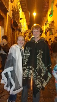
Haley and I wearing our ponchos to dinner in Quito.
|
Day 13 (1/13/18)
|
Draining water in each hemisphere.
|
Day 13 had a slow start; one of our fellow students had been feeling ill for a few days, so we all waited on the bus for a few hours while he was seeing a doctor. Once he had returned, we headed to La Mitad del Mundo (the real equator, not the fake monument built by the French). While there, we saw a variety of tourist-y equator gags, such as the Coriolis Effect changing how water drained from a washtub (clockwise in the southern hemisphere, counterclockwise in the northern hemisphere). We also saw a recreation of a recreation of Quitus-Caras burial pod (they symbolized rebirth into the afterlife), as well as a ~200 year old indigenous house complete with a cui pen.
|
|
We didn't have much time to spend at the equator due to our late start, so we soon departed for the cloud forest; Sachatamia Lodge, our hotel, was just outside the small village of Mindo. When we got there, I was immediately struck by the amazing variety and abundance of hummingbirds (and the rain, which basically never stopped). After settling into my room for a few minutes, I went back to the main porch to sit and watch the hummingbirds compete for flower and feeder space. As a photographer, I really enjoyed the challenge of getting nice hummingbird shots; the low light, high humidity, and speed of the birds made it really difficult, but I'd like to think I somewhat succeeded. |
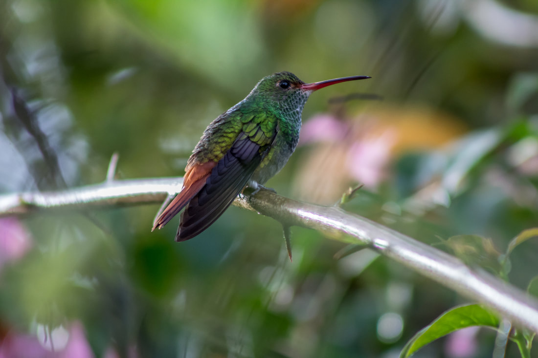
A Rufuos tail hummingbird in Mindo.
|
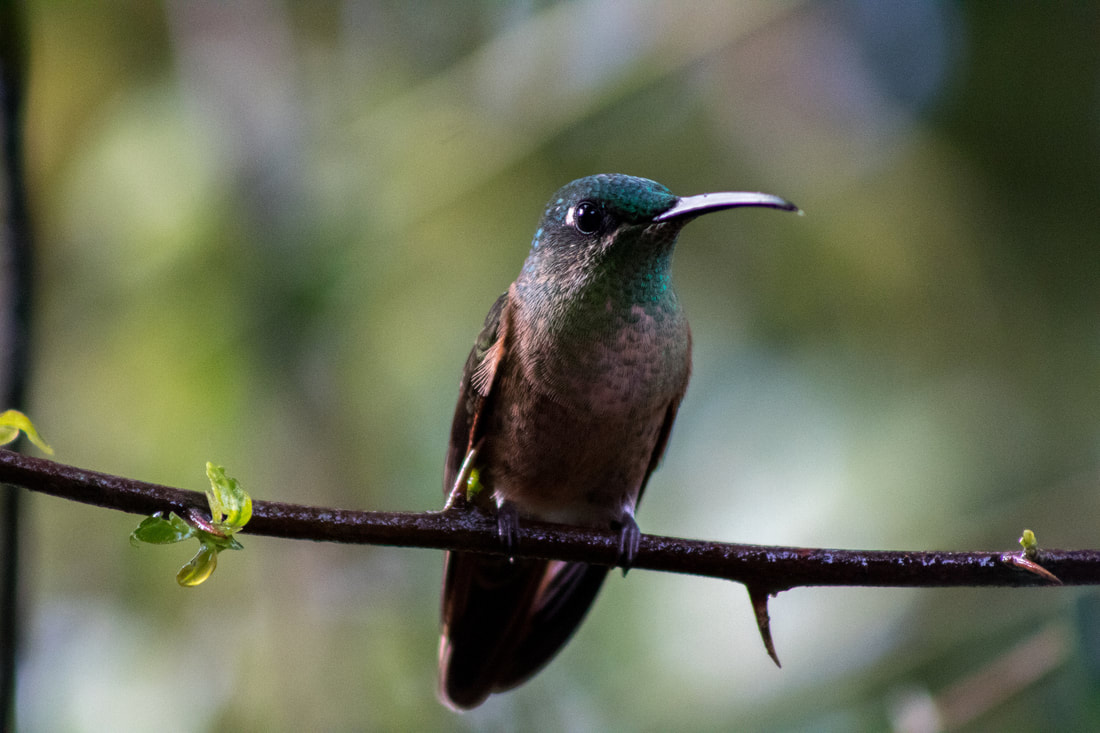
A fawn-breasted brilliant in Mindo.
|
I watched the hummingbirds for a while until we ate lunch; afterwards, we reflected on our Quito bus experience and the Pacari chocolate tasting. By that time, our suspicions and questions regarding Pacari's supposed sustainability had reached their highest level; unfortunately, we had to keep quiet about it with Diego, since his wife's cousin is one of the company's founders. Following our reflection, we ate dinner and listened to Victoria and Laurel's presentation on the treadmill of production, then headed off to our rooms to sleep. Day 14 was our last full day in Ecuador, and we wanted to make the most of it. |
Day 14 (1/14/18)
|
I woke up early on Day 14 to get some hummingbird photos before breakfast. Luckily, the rain had temporarily let up- and I wanted to make the most of it. We ate a nice assortment of fruits and eggs for breakfast, and then headed off to explore the cloud forest. As we walked down the trail (which was conveniently on Sachatamia Lodge property), we learned that the cloud forest is home to a variety of famous wildlife, such as toucans, spectacled bears, and tamarins (although we unfortunately didn't see any). Since this was the closest we got to the Amazon, Diego also took the time to teach us about some Amazonian folklore. Hummingbirds, for example, are believed to have stolen fire from the devil for us humans. Jaguars bring good luck; the pink river dolphins, however, bring bad luck. This distrust of the river dolphins was supposedly hard to overcome; it was difficult to teach the indigenous peoples that the dolphins are good for tourism.
|
A typical cloud forest scene. Notice the wide variety of vegetation.
|
As we neared the end of our trail, we crossed a small river. We stopped for a few minutes before we turned around; Tait took the time to explain that people pan rivers near Mindo for gold. This became a problem when people started using mercury to amalgamate the gold (to make it easier to collect); many of the local rivers have been contaminated with mercury as a result.
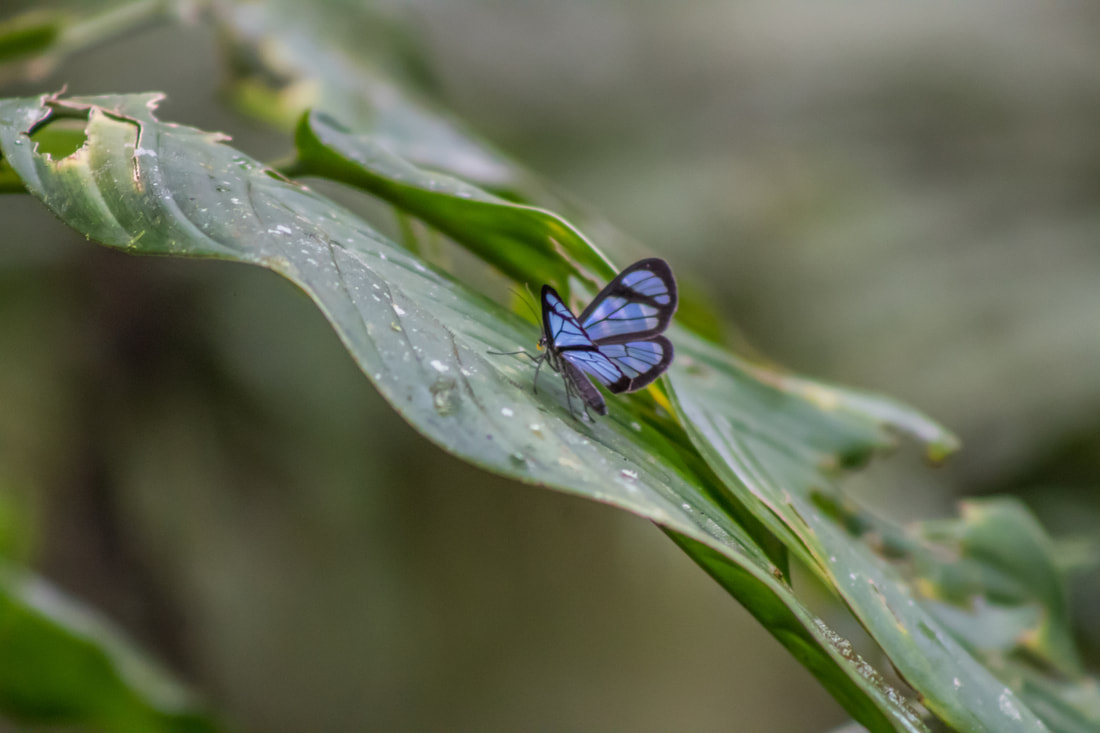
A blue glasswing butterfly we spotted along the Sachatamia Lodge trail.
|
After our first walk, some of us chose to explore a bit more down the road. We didn't see much in terms of wildlife, but we did find some wild raspberry bushes and a few cows. After about 20 minutes it began to rain, so we turned around; we ate lunch at the hotel, and then took a couple taxis across town to go ziplining. I had only been on a professional zipline course once before, so I was excited to try it again, especially in a place as beautiful as Mindo. Although it stopped raining for the first 1/3 of our canopy tour, it started pouring for the remainder. Ziplining in the rain was quite the experience; it felt more like a waterslide than anything else. Minus the uncomfortable walk to the next line, it may have been even more fun than ziplining in the sun. |
Before heading back to Sachatamia Lodge, we stopped briefly at the markets in Mindo for some last-minute souvenirs and fresh fruit. After dinner (back at the lodge), we reflected on the trip as a whole, discussing what we liked/disliked and what could be done differently next time. It was sad to think that our trip was coming to an end; but, I had enjoyed every second of it, and would do it all again in a heartbeat (except getting stabbed by the sea urchins- I think I've had enough of that).
Day 15 (1/15/18)
Day 15 was tough. Not only did we have to say our goodbyes to Mindo- we had to say our goodbyes to Ecuador. Our first flight took us from Quito back to Guayaquil; we waited there (and stocked up on Pacari chocolate) for a few hours before our flight back to JFK departed. We had another short layover in Colombia (where I bought some more chocolate), but before long we were back in the United States (technically it was the 16th when we landed, since we flew through the night).
The Ecuador 2018 Field Experience was truly life-changing. Many of the places we'd visited were places I had seen on TV or read about in books and magazines; I never thought I would have the opportunity to go in person. I was extremely fortunate to experience it all with such a fantastic group of students, and through a class that taught me so much. If you're reading this, and thinking about taking International Sustainable Development in the future, I can't recommend it enough. ¡Ama la vida!
Please click the albums below to view all of my Quilotoa, Cotopaxi, Mito del Mundo, and Mindo pictures in full resolution on Flickr.
Quilotoa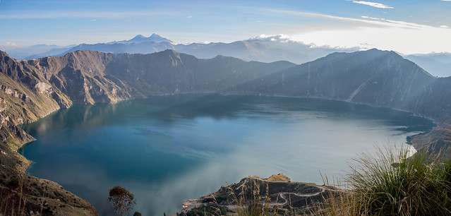 |
Cotopaxi |
La Mitad Del mundo |
Mindo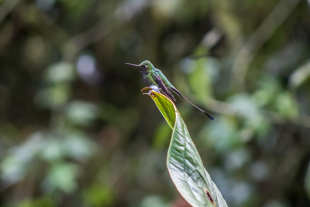 |
